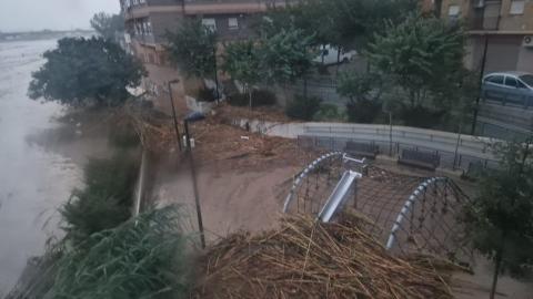
Our partners in Valencia
While still reeling from the shocking impacts of these floods, people want to know how this could happen and if it can be prevented in the future. It is complex but understanding the regional circumstances and learning from each other is what Interreg Europe projects are all about.
Fragmented responsibilities
In Valencia, the Xúquer River Basin covers most of the province, with a miriad of small streams and water bodies. Rivers are state owned and managed by the Júcar Hydrographic Confederation (JHC), while in urban areas local authorities are responsible for management works. The regional government oversees emergency management and the civil protection service, monitoring data provided by the AEMET (National Meteorological Agency) and the JHC.
The recent heavy rain was linked to a phenomenon known as DANA (Isolated Depression at High Levels in Spanish), which occurs when cold air moves over the hot waters of the Mediterranean, generating an atmospheric instability as dense clouds can remain over the same area for hours, potentiallly potential unleashing high impact rainfall.
Extraordinary events
On 29/30 October, the accumulated rainfall in some parts of the basin way surpassed their annual average. A weather station in Turís received 771 l/m² in 24 hours, according to AEMET (185of which accumulated in just one hour). To better understand the magnitude of these numbers, historical records show that the average annual rainfall in Turís is 475 l/m². Meanwhile, it hardly rained in the lower part of the basin, leading to a false sense of security for people in the most affected municipalities.
Due to these extraordinary events, some rivers that normally run dry surpassed the average flow of the Nile (2.830 m³/s): according to the latest calculations and hydraulic models offered by the Júcar Hydrographic Confederation, the Poyo ravine achieved a peak flow of more than 3.500 m3/s (the gauging station was destroyed when it reached 2.282 m3/s). That exceeds the assigned statistical period of occurrence of once every 500 years.

Land Use Planning& Flood Risk
Flood and hazard maps are clear: flood risk increases when urban growth compromises natural drainage and storage areas, increases impervious cover, and reduces the infiltration capacity of soils. Those affected basins have a high degree of waterproofing and a huge urban development that obstructed or concentrated the flow in areas where the water should naturally disperse, increasing the hazardous flash flood and its degree of devastation.
There is a huge deal regarding land occupation: a large part of the affected towns is located inside a natural area of convergence-divergence of waters from the entire river network, taking up space from the flood plain. People need to be aware of this, because water will always seek its natural outlet during times of flooding and, in a context of climate change, new models of water governance and management should emerge, respecting the blue-green infrastructure.
Climate change
Experts have long been pointing to an increase in intense and sudden river floods in the mediterranean ravines. The increase in so-called “flash floods” is linked to climate change, in a context of increasing risks. Some of the devastated places in Valencia share a risk of flooding every 100 or 500 years. However, with climate change and the current virulence of floods, these return periods are changing and need to be readjusted. Climate change is disrupting rainfall patterns and putting our health at risk, with both droughts and extreme rainfall becoming more and more common.
Communities & cooperation
In RIWET, Valencia Province and the LIMNE Foundation cooperate with consortiums and local governments from 13 different municipalities and NGOs to increase the effectiveness of existing policies. They are engaging local communities more by creating stewardship groups to support monitoring, maintenance, and long-term river restoration results.
Interreg Europe finding solutions
The warming climate was also a contributing factor to the acuteness of the floods that overwhelmed northern France in 2023, when heavy rain caused river levels to rise. The inundations revealed the dangers of climate change in low-lying regions and triggered the Interreg Europe to initiate a recent peer review.
Although both this new reality and its impacts are complex, we need to find solutions, focusing on education and social awareness, as well as new territorial planning and achieving key aspects for sustainable urban development - such as a combination of engineering solutions and nature-based measures. It is crucial to improve governance to avoid the same problems in the future.
We’ll keep you updated on RIWET progress and hope to witness the work being done in Valencia when the partnership visits the area in March 2025.
